
Coastal communities in the U.S. have a 26% chance of flooding within a 30-year period. This percentage is expected to increase due to climate-change-driven sea-level rise, making these areas even more vulnerable.
Michael Beck, professor and director of the UC Santa Cruz Center for Coastal Climate Resilience, focuses on modeling and mapping the benefits of coral reefs and mangroves for reducing flood risk, which helps inform adaptation and preservation efforts.
Beck and his team produce detailed, NVIDIA GPU-accelerated visualizations of coastal flooding to help government agencies, nongovernmental organizations and financial organizations better understand flood risks and demonstrate how nature-based solutions can mitigate damages on shore.
“We view visualizations as fundamental to motivating action,” said Beck. “These are difficult problems revolving around people, some of them expensive to fix, so you’ve got to be able to visualize the solutions and ensure they’re going to work.”
To accelerate the simulations, the center uses NVIDIA CUDA-X software, including the cuPyNumeric library and nvfortran compiler, running on NVIDIA RTX GPUs awarded through the NVIDIA Academic Grant Program.
Accelerating Flood Mapping With NVIDIA GPUs
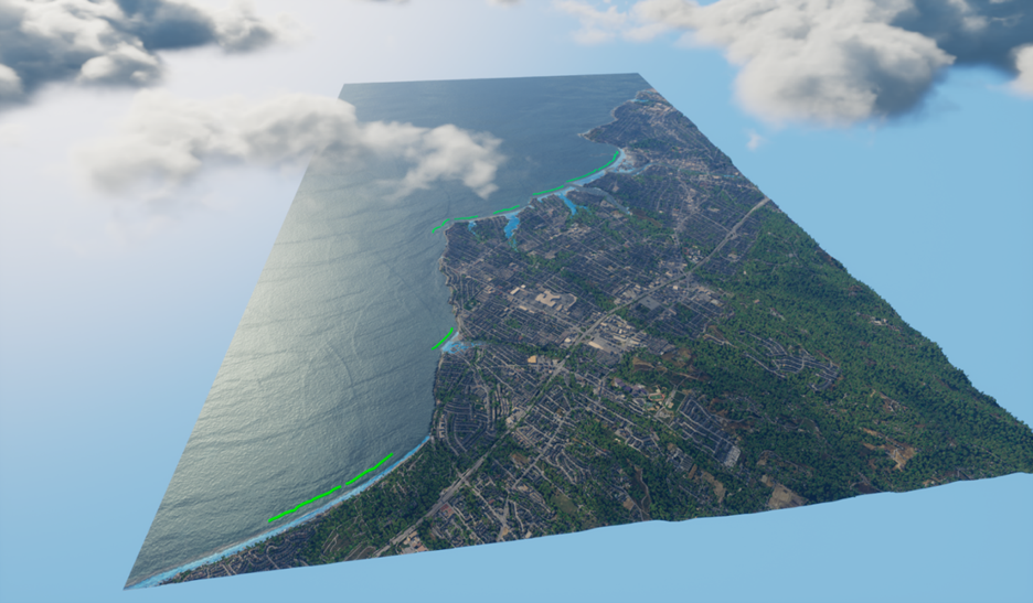
Flood modeling starts with a question such as, “What would happen to Santa Cruz, California, in the event of a 100-year storm?”
To answer that question, the research team uses simulation tools such as SFINCS and feeds the results into the Unreal Engine 5 rendering engine to produce data-driven videos showing various flooding scenarios.
Beck’s team accelerated their flood risk models and visualizations from a process that originally took approximately six hours on CPU workloads to just about 40 minutes using a single NVIDIA RTX 6000 Ada Generation GPU. With the team’s cluster of four GPUs, they can now run four simulations simultaneously.
“We were able to reduce the computation by 3-4x, with some workloads being even faster,” said David Gutiérrez, senior coastal modeler at UC Santa Cruz’s Center for Coastal Climate Resilience. “This speedup gave us the capacity to run a sensitivity analysis beforehand and make sure we’re not making any assumptions or setting the wrong parameters.”
Less time spent on modeling and visualizing each site meant the researchers could set more ambitious, global goals for their project.
Digital Flood Mapping Goes Global
The team’s current endeavor is to map all small-island developing states globally — from Tonga to Trinidad and Tobago — before the COP30 climate change conference in November.
“The kind of high-resolution modeling that we’re doing is very tricky,” Beck said. “We’re trying to show not just weather and the problems that weather creates, but run scenarios with solutions.”
Put Your Money Where the Marine Life Is
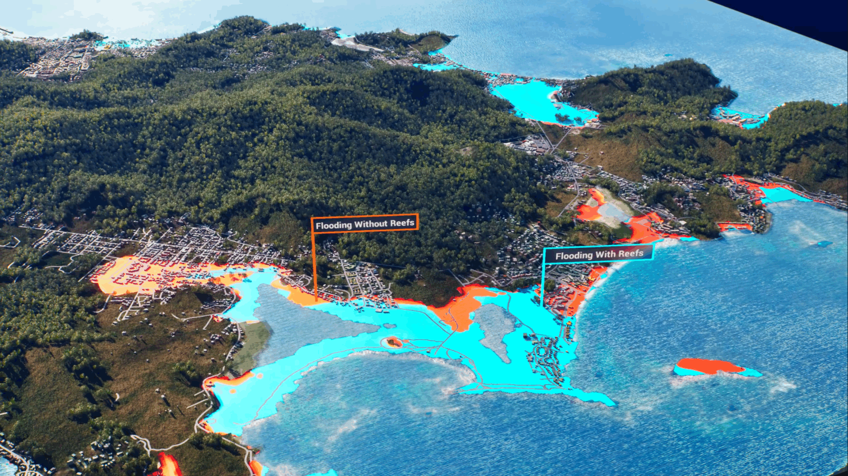
One way to motivate coral reef preservation is by insuring them based on their value as natural infrastructure, capable of serving as a line of defense during climatic events.
This is already becoming a reality in places like the Mesoamerican Barrier Reef in Mexico, south of Cancun on the Mayan Riviera.
Through his work with The Nature Conservancy, Beck presented visualizations of reefs in the event of a hurricane to interested parties, including hotel owners along the coast, the Mexican government and World Bank Group.
These groups ended up investing in a parametric insurance policy to protect the coral reef, which stipulated that if the wind reached over 100 knots, a payout would be triggered to restore the damaged reef.
“To motivate action, you have to understand and visualize a bit more about the increasingly risky storm events that we’re facing right now, because of where they’re developing and the impacts of climate change,” said Beck.
Other regions throughout the Caribbean and Hawaii are also starting to adopt similar policies.
Insurance policies like this help ensure that funding is available to restore reefs after storms — protecting coastal communities against further, more severe flooding damage.
“You’ve got all these coral heads and the waves damage them, so you need to either take them to a nursery or cement them back on the reef,” Beck said. “Also, you need to get all the trash off that comes back out with the flood from the land — everything from fishing nets to refrigerators — that’s the flotsam and jetsam of our life.”
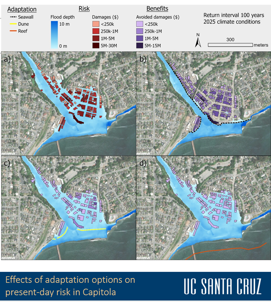
These researchers are now working toward modeling flooding across California’s coastal regions through a project called CoSMoS ADAPT.
The project’s primary goal is to strengthen the USGS’s Coastal Storm Modeling System (CoSMoS), which is the first toolkit for quantitative evaluation of the cost-effectiveness of the state’s coastal adaptation options, including nature-based solutions.
“CoSMoS predicts what risks will be now and into the future,” Beck said. “We’re adding the solutions that will reduce the risk — from dunes to sea walls and our reefs — and at a variety of levels, this is going to demand acceleration and heavy computation.”
Apply for an NVIDIA Academic Grant
The NVIDIA Academic Grant Program is calling for research proposals now through Wednesday, Dec. 31, to advance work in three interest areas: generative AI and model development, generative AI alignment and inference, and robotics and edge AI. Full-time faculty members at accredited academic institutions are eligible to apply.
Learn more about the NVIDIA Academic Grant Program.
Main video above shows visualization of the data layers used in a 2D wave and flood model for assessment of reef and restoration benefits in Christiansted, a town in Saint Croix, one of the U.S. Virgin Islands.
